Uganda Country Map: A Comprehensive Guide to Geography, Location, and Key Features
Introduction
Uganda, often referred to as the “Pearl of Africa,” is a fascinating country in East Africa. Positioned just south of the equator, Uganda is a landlocked country that offers a rich blend of cultural, historical, and natural beauty. Its location, marked on the world map, places it at a crossroads of East and Central Africa. This article provides a comprehensive guide to Uganda’s country map, discussing its geographical features, neighboring countries, key landmarks, and more. Understanding Uganda’s position on the world map is essential for anyone interested in learning about the country, whether for academic purposes, tourism, or general curiosity.
Geographical Overview of Uganda
Uganda’s geography is as diverse as its culture. Covering an area of approximately 241,038 square kilometers, Uganda is the 82nd largest country in the world. Situated in East Africa, it is bordered by five countries: Kenya to the east, South Sudan to the north, the Democratic Republic of the Congo (DRC) to the west, Rwanda to the southwest, and Tanzania to the south. Uganda’s location along the Great Rift Valley, combined with its proximity to Lake Victoria, shapes its diverse terrain.
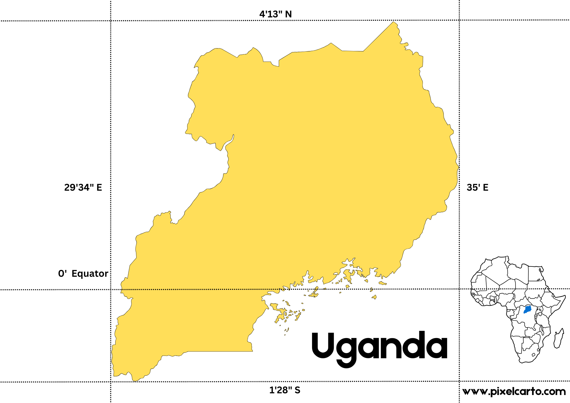
Uganda’s Location on the World Map
Looking at the world map, Uganda is located near the equator, at approximately 1° N latitude and 32° E longitude. Its position in East Africa gives it a central place on the continent, which makes it easily accessible to other parts of Africa. Uganda is one of the few countries that are directly influenced by both tropical and temperate climates due to its location across the equator.
Uganda’s proximity to Lake Victoria, which it shares with Kenya and Tanzania, enhances its natural beauty. The lake itself is an essential feature of the country’s geography and serves as a vital resource for the people living in the region.
Neighboring Countries and Borders
Uganda shares borders with five countries, each of which contributes to its geopolitical significance. Let’s take a closer look at Uganda’s neighbors:
- Kenya: To the east of Uganda lies Kenya, which shares a long border with Uganda. The two countries share historical, cultural, and economic ties. Kenya is a major trading partner and an important regional power in East Africa.
- South Sudan: To the north of Uganda is South Sudan, the world’s youngest country. The border between Uganda and South Sudan is often marked by conflict, but both countries have been working together to ensure peace and stability in the region.
- Democratic Republic of the Congo (DRC): To the west of Uganda, the DRC is a massive country with diverse landscapes. The two countries share a border along the Great Lakes region. Uganda and the DRC have complex political and economic relations, but they both benefit from cross-border trade and resource sharing.
- Rwanda: To the southwest, Uganda shares a border with Rwanda, a country known for its mountainous terrain and stunning landscapes. Rwanda and Uganda have a long history of cooperation, and the two nations share both cultural and economic ties.
- Tanzania: To the south of Uganda is Tanzania, which shares a significant portion of Lake Victoria with Uganda. The two countries share a deep bond that extends to various sectors, including trade, tourism, and infrastructure development.
Topography and Terrain of Uganda
Uganda’s terrain is as diverse as its neighboring countries. It features a wide range of natural landscapes, including savannas, mountains, forests, and wetlands. Uganda is located within the Great Rift Valley, a geological feature that stretches from the Middle East to Southern Africa. The country’s topography is a result of both the Rift Valley and the surrounding highlands.
- Highlands and Mountains: The western part of Uganda is dominated by mountains, including the Rwenzori Mountain Range, which forms part of the border with the Democratic Republic of the Congo. The Rwenzori Mountains are famous for their snow-capped peaks, which is a rare sight near the equator. The mountains are also a UNESCO World Heritage Site and are home to several species of plants and animals that are unique to the region.
- Lakes and Rivers: Uganda is known for its large lakes, including Lake Victoria, the world’s second-largest freshwater lake. Other significant bodies of water in the country include Lake Albert, Lake Edward, and Lake Kyoga. These lakes, along with the Nile River, provide crucial water resources to the country and are a significant part of Uganda’s economic and ecological systems.
- Savannas and Forests: Uganda’s landscapes also include vast stretches of savanna grasslands and tropical forests. The savannas are primarily located in the central and eastern parts of the country, while the forests are found in the west and southwest, particularly in the areas around Bwindi Impenetrable Forest and Kibale National Park. These forests are famous for their biodiversity, including endangered species like the mountain gorilla.
Climate and Weather Patterns in Uganda
Uganda enjoys a tropical climate, characterized by both wet and dry seasons. Due to its location along the equator, Uganda experiences moderate temperatures year-round, with average highs ranging from 25°C to 30°C (77°F to 86°F). The country’s weather patterns are influenced by its diverse terrain, with the highland regions experiencing cooler temperatures, while the lowland areas remain warmer.
- Rainy Seasons: Uganda typically experiences two rainy seasons—one from March to May and another from October to December. These rainy periods are important for agriculture and water resources. The rainfall also supports Uganda’s lush landscapes and biodiversity.
- Dry Seasons: Uganda’s dry seasons generally occur between December and February and June to August. During these months, the country experiences less rainfall, and temperatures can rise slightly, especially in the northern and eastern regions.
Cultural and Ethnic Diversity in Uganda
Uganda is home to over 56 ethnic groups, each with its own unique language, customs, and traditions. The most prominent ethnic groups include the Baganda, Basoga, Banyankole, Bakiga, Banyarwanda, and many others. The country’s diverse population is one of its greatest assets, contributing to a vibrant culture and dynamic society.
- Linguistic Diversity: Uganda’s official languages are English and Swahili, but there are many other languages spoken across the country. Luganda is the most widely spoken indigenous language, especially in the central region. Other languages include Runyankore, Rukiga, and Luo.
- Cultural Practices: Ugandan culture is rich in traditions, including dance, music, art, and cuisine. Traditional ceremonies, such as weddings and rites of passage, are important cultural practices in many Ugandan communities. The Ugandan people celebrate their cultural diversity through festivals and events, which attract tourists and locals alike.
Uganda’s Economy and Natural Resources
Uganda’s economy is largely based on agriculture, with coffee being the country’s main export product. The country also has significant mineral resources, including gold, cobalt, and copper, which contribute to its growing economy. Uganda is investing in infrastructure and industrial development, with a focus on improving transportation and energy sectors.
- Agriculture: Uganda is known for producing agricultural products like coffee, tea, cotton, and tobacco. These crops are essential for the country’s economy and are exported to international markets.
- Natural Resources: Uganda is rich in natural resources, including fertile land for farming and vast water resources. The discovery of oil reserves in the western part of the country has attracted international investment, and Uganda is poised to become a significant oil producer in Africa.
Tourism in Uganda
Uganda is a premier tourist destination in Africa, attracting visitors for its wildlife, scenic beauty, and cultural experiences. Uganda’s national parks and game reserves, such as Bwindi Impenetrable Forest, Queen Elizabeth National Park, and Murchison Falls National Park, offer visitors the opportunity to experience Africa’s wildlife up close. Uganda is also famous for its conservation efforts in protecting endangered species like the mountain gorilla.
Conclusion
Uganda’s country map is marked by geographical diversity, cultural richness, and economic potential. From the snow-capped peaks of the Rwenzori Mountains to the pristine shores of Lake Victoria, Uganda offers a unique blend of natural beauty and cultural heritage. Understanding Uganda’s location and geography is essential for appreciating the country’s significance on the global map. Whether you’re interested in its wildlife, landscape, or vibrant cultural heritage, Uganda continues to be an attractive destination for travelers, investors, and researchers alike.